Spatial analysis of the exposure to flooding of educational centers in Orihuela (Alicante)
DOI:
https://doi.org/10.37230/CyTET.2024.219.8Keywords:
Flood, Exposition, Educational centers, Spatial analysis, Orihuela, AlicanteAbstract
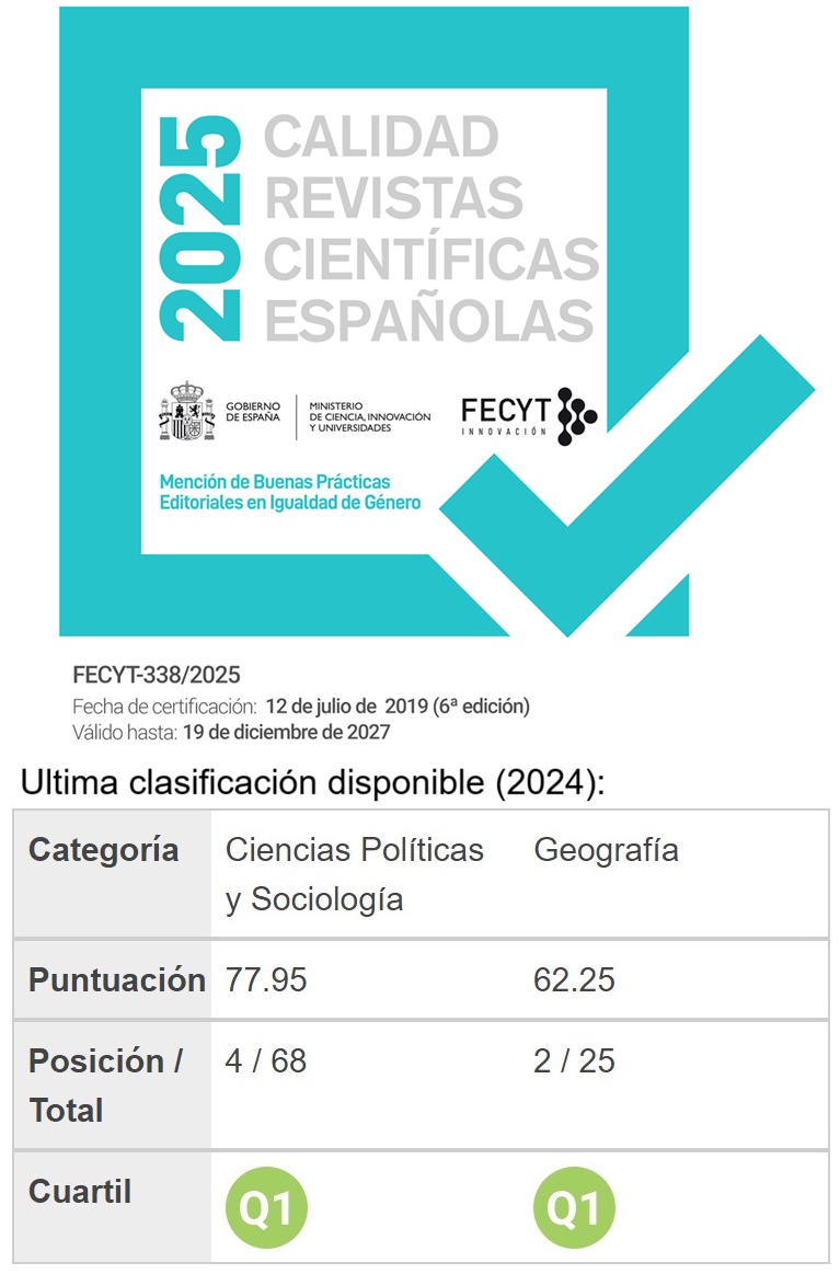
The city of Orihuela (Alicante, Spain) is located in one of the most important flood risk areas of the Iberian peninsula (Segura river). The aim of this research is to identify the educational centres exposed to floods according to the Territorial Action Plan against Flood Risk of the Valencian Community (PATRICOVA) and the National Mapping System of Floodable Areas (SNCZI) with the cadastral cartography. The results show that 19 of 25 of Primary Education schools and 9 of 12 Highs schools are totally or partially exposed. This percentage increases if the accesses are analysed since all the centres (n=31) are exposed to floods. It has been verified that there are no differences according to the educational stages and the management of the centre. Given the high exposure of educational centres and the concentration of people, it is considered that they are one of the main areas that should be taken into account when proposing management, adaptation and social-territorial resilience measures to the current and future climate change scenarios.
Downloads
References
ARAUZ, J. (2008): Reflexiones sobre la educación de la prevención del riesgo de desastres. Tecnología en Marcha, 21 (1), 202-214.
AZMI, E.S. & RAHMAN, H.A. & HOW, V. (2020): A Two-Way Interactive Teaching-Learning Process to Implement Flood Disaster Education in an Early Age: The Role of Learning Materials. Malaysian Journal of Medicine and Health Sciences, 16 (11), 166-174.
BRICEÑO, S. (2006): La reducción de desastres empieza en la escuela. Campaña mundial para la Reducción de Desastres. Naciones Unidas. https://www.eird.org/cd/toolkit08/material/Inicio/escuela_segura/capitulo_1.pdf
CALVO, F. (2001): Sociedades y Territorios en Riesgo. Barcelona, España, Ediciones Serbal.
CANALES, G. (1995): El Bajo Segura: Estructura espacial, demográfica y económica. Alicante, España, CAM Fundación Cultural.
CANALES, G. & RUÍZ, M. & TRIGUEROS, J.C. & VALORIA, J. & VÀREZ, M.V. (2016): Orihuela, una ciudad rodeada de jardines. Orihuela, España, Concejalía de Turismo, Ayuntamiento de Orihuela.
GIL, A. & CANALES, G. (2023): Concausas y tipos de inundaciones en la Vega Baja del Segura. Alicante, España, Servicio de Publicaciones de la Universidad de Alicante.
CENTENO, J. & SORIANO, B. (2022): Análisis de los 7 eventos más importantes cubiertos por el Consorcio de Compensación de Seguros en la serie 2009-2021. Consorseguros: Revista Digital, 16, 1-14. https://www.consorsegurosdigital.com/es/numero-10/sumario/analisis-de-los-7-eventos-mas-importantes-cubiertos-por-el-consorcio-de-compensacion-de-seguros-en-la-serie-2009-2021
CONSELLERIA DE EDUCACIÓN, CULTURA Y DEPORTE. EDUCACIÓN Y FORMACIÓN PROFESIONAL (2023): Guía de centros. Consulta general. https://ceice.gva.es/es/web/centros-docentes/consulta-general
CONSELLERIA DE POLÍTICA TERRITORIAL, OBRAS PÚBLICAS Y MOVILIDAD (2019): Guía de Aplicación del Plan de Acción Territorial sobre Prevención del Riesgo de Inundación en la Comunidad Valenciana (PATRICOVA). PATRICOVA. https://politicaterritorial.gva.es/documents/20551069/167206402/Gu%C3%ADa+PATRICOVA+%28castellano%29.pdf/e1a0b83a-8846-45fa-aff7-0d98b5b4fcc0?t=1574072184771
CONSELLERIA DE POLÍTICA TERRITORIAL, OBRAS PÚBLICAS Y MOVILIDAD (2023): Plan de Acción Territorial de carácter sectorial sobre Prevención del Riesgo de Inundación en la Comunidad Valenciana (PATRICOVA). PATRICOVA. https://politicaterritorial.gva.es/es/web/planificacion-territorial-e-infraestructura-verde/patricova-docs
CONSELLERIA DE VIVIENDA, OBRAS PÚBLICAS Y VERTEBRACIÓN DEL TERRITORIO (2015): Plan de Acción Territorial sobre Prevención del Riesgo de Inundación en la Comunitat Valenciana (PATRICOVA). Normativa. Dirección General de Ordenación del Territorio, Urbanismo y Paisaje. https://politicaterritorial.gva.es/documents/20551069/162377494/02+Normativa.pdf/5d2bca03-0f7f-4774-b602-4447cfb8dce7?t=1446539226342
CUELLO, A. (2018): Las inundaciones del invierno 2009-2010 en la prensa, un recurso educativo para las ciencias sociales. REIDICS: Revista de Investigación en Didáctica de las Ciencias Sociales, 2, 70-87. https://mascvuex.unex.es/revistas/index.php/reidics/article/view/3039
CUELLO, A. (2022): Los entornos fluviales urbanos como recurso para la educación ambiental: estudio de casos en los ríos Guadalquivir y Guadalete en Andalucía. Tesis Doctoral. Universidad de Sevilla.
CUELLO, A. & CUELLO, M. (2017): Crecimiento urbano y espacio fluvial. Una mirada educativa. En: M.T. PÉREZ & D. NAVAS (Coords.), Periferias urbanas: La regeneración integral de barriadas residenciales obsoletas (pp. 216-232). Sevilla, España, Departamento de Urbanística y Ordenación del Territorio. https://idus.us.es/handle/11441/57614
CUELLO, A. & GARCÍA F. (2019): ¿Ayudan los libros de texto a comprender la realidad fluvial de la ciudad? Revista de Humanidades, 37, 209-234. https://doi.org/10.5944/rdh.37.2019.22895
DÍEZ HERRERO, A. & HERNÁNDEZ, M. (2020): Mejora de la percepción y conocimiento infantil sobre el riesgo de inundaciones: programa “Venero Claro-Agua (Ávila). En: I. LÓPEZ & J. MELGAREJO & FERNÁNDEZ, P. (Eds.), Riesgo de inundación en España: análisis y soluciones para la generación de territorios resilientes (pp. 1201-1210). Orihuela, España, Diputación Provincial de Alicante.
DÍEZ HERRERO, A. & HERNÁNDEZ, M. & DÍEZ, P. & CARRERA, C. (2020): Programa de educación infantil en el riesgo de inundaciones “Venero Claro-Agua” (Ávila). Riesgo de inundación en España: análisis y soluciones para la generación de territorios resilientes. En: I. LÓPEZ & J. MELGAREJO & FERNÁNDEZ, P. (Eds.), Riesgo de inundación en España: análisis y soluciones para la generación de territorios resilientes (pp. 1191-1200). Orihuela, España, Diputación Provincial de Alicante.
DÍEZ HERRERO, A. & HERNÁNDEZ, M. & VÁZQUEZ, D. & VELASCO, M. (2021a): Incorporación de contenidos sobre el riesgo de inundación en la educación vial. En: J. MELGAREJO & I. LÓPEZ & FERNÁNDEZ, P. (Eds.), Inundaciones y sequías. Análisis Multidisciplinar para Mitigar el Impacto de los Fenómenos Climáticos Extremos (pp. 225-236). Orihuela, España, Diputación Provincial de Alicante.
DÍEZ HERRERO, A. & GARCÍA, E. & MARTÍN, C. & SACRISTÁN, N. & VICENTE, M.F. (2021b): La educación en el riesgo como medida preventiva de desastres naturales. Publicaciones del Instituto Geológico y Minero de España. Serie: Riesgos geomorfológicos/geotecnia. https://www.igme.es/publicaciones/publiFree/ATODORIESGO.pdf
GENERALITAT VALENCIANA (2023): Infraestructura de Datos Espaciales Valenciana (IDEV). https://idev.gva.es/va/inicio
GIL, A. & OLCINA, J. (2017): Tratado de climatología. Alicante, España. Servicio de Publicaciones de la Universidad de Alicante.
INTERGOVERNMENTAL PANEL ON CLIMATE CHANGE (IPCC) (2022): Special Report Global warming of 1.5ºC. https://www.ipcc.ch/report/ar6/wg2/
La Verdad (27 de febrero de 2023): La Vega Baja formará a sus escolares sobre el riesgo de inundaciones. La Verdad. https://www.laverdad.es/orihuela-torrevieja/vega-baja-formara-20230227202344-nt.html
LAVILLA, E. (14 de septiembre, 2019): Gota fría: otro fallecido en Orihuela eleva a seis las víctimas del temporal. El Confidencial. https://www.elconfidencial.com/espana/2019-09-14/dana-seis-muertos-tormentas-extienden-centro-pais-alerta-murcia_2229519/
LILLO, J. (1998): Aproximación a la interpretación de un problema ambiental en enseñanza secundaria: los desbordamientos periódicos del río Sar en Padrín con ocasión de lluvias más copiosas de lo normal. III Jornadas sobre el medio natural en Galicia: presente y futuro de la Educación Ambiental. Sociedad de Ciencias de Galicia. Septiembre de 1998. http://mol.scg.org.es/wp-content/uploads/2016/04/Mol-06.pdf
LLASAT, M. C. (2021): Floods evolution in the Mediterranean region in a context of climate and environmental change. Cuadernos de investigación geográfica: Geographical Research Letters, 47 (1), 13-32. https://doi.org/10.18172/cig.4897
MARTÍ, J. & AMOR, J.A. & GIMÉNEZ, R. & RUIZ-ÁLVAREZ, V. & BIENER, S. (2021): Episodio de lluvias torrenciales del 11 al 15 de septiembre de 2019 en el sureste de la Península Ibérica: Análisis meteorológico y consecuencias de las transformaciones en los usos del suelo. Finisterra: Revista Portuguesa de Geografia, 56 (117), 151-174. http://rua.ua.es/dspace/handle/10045/117475
MARTÍNEZ RUBIANO, M. (2010): El lugar de la educación geográfica en la disminución de la vulnerabilidad ante los riesgos ambientales. Unipluriversidad, 10 (3), 163-176.
MINISTERIO DE HACIENDA Y FUNCIÓN PÚBLICA, DIRECCIÓN GENERAL DEL CATASTRO (2023): Servicios INSPIRE de Cartografía Catastral. https://www.catastro.minhap.es/webinspire/index.html
MINISTERIO PARA LA TRANSICIÓN ECOLÓGICA Y EL RETO DEMOGRÁFICO (2023a): Cronología de riadas en la cuenca del Segura. Confederación Hidrográfica del Segura. Cronología de riadas en la cuenca del Segura (chsegura.es)
MINISTERIO PARA LA TRANSICIÓN ECOLÓGICA Y EL RETO DEMOGRÁFICO (2023b): Sistema Nacional de Cartografía de Zonas Inundables (SNCZI). https://www.miteco.gob.es/es/agua/temas/gestion-de-los-riesgos-de-inundacion/snczi/
MINISTERIO PARA LA TRANSICIÓN ECOLÓGICA Y EL RETO DEMOGRÁFICO (2023c): Valores climatológicos normales: Precipitación acumulada (mm). Servicios climatológicos. Agencia Estatal de Meteorología. https://www.aemet.es/es/serviciosclimaticos/datosclimatologicos/valoresclimatologicos
MOHD, W. & NOR, W. & AMAN, N. & SUKERI, S. & HASSAN, H. & MOHAMED, Z. & YEH, L.Y., BESARI, A.M. & DRAMAN, N. & ZAKARIAS, R. (2020): Effectiveness of community-based health education on preparedness for flood-related comunicable diseases in Kelantan. Malaysian Journal of Public Health Medicine, 20 (3), 117-124. https://doi.org/10.37268/mjphm/vol.20/no.3/art.647
MOROTE, A. F. (2017): El parque inundable “La Marjal” de Alicante (España) como propuesta didáctica para la interpretación de los espacios de riesgo de inundación. Didáctica Geográfica, 18, 211-230. https://didacticageografica.age-geografia.es/index.php/didacticageografica/article/view/390
MOROTE, A. F. & HERNÁNDEZ, M. (2022): What Do School Children Know about Climate Change? A Social Sciences Approach. Social Sciences, 11 (179), 1-17. https://doi.org/10.3390/socsci11040179
MOROTE, A. F. & OLCINA, J. (2021): La enseñanza del riesgo de inundación en Bachillerato mediante Sistemas de Información Geográfica (SIG). El ejemplo del PATRICOVA en la Comunidad Valenciana (España). Anales de Geografía de la Universidad Complutense, 41(2), 431-461. https://doi.org/10.5209/aguc.79344
MOROTE, A. F. & PÉREZ MORALES, A. (2019): La comprensión del riesgo de inundación a través del trabajo de campo: una experiencia didáctica en San Vicente del Raspeig (Alicante, España). Vegueta. Anuario de la Facultad de Geografía e Historia, 19, 609-631. https://revistavegueta.ulpgc.es/ojs/index.php/revistavegueta/article/view/470
MOROTE, A. F. & SOUTO, X. M. (2020): Educar para convivir con el riesgo de inundación. Estudios Geográficos, 81 (288), 1-14. https://doi.org/10.3989/estgeogr.202051.031
MOROTE, A. F. & OLCINA, J. & HERNÁNDEZ (2022): How is flood risk explained in the subject of Geography in Spanish schools? An approach based on Social Science textbooks (Primary Education). International Research in Geographical and Environmental Education, 1-17. https://doi.org/10.1080/10382046.2022.2133955
OLCINA, J. (2021): Inundaciones de septiembre de 2019 en la Vega Baja del Segura. La oportunidad del Plan “Vega Renhace”. Geographicalia, 73, 243-271. https://rua.ua.es/dspace/handle/10045/116969
OLCINA, J. & MOROTE, Á.F. & HERNÁNDEZ, M. (2022): Teaching Floods in the Context of Climate Change with the Use of Official Cartographic Viewers (Spain). Water, 14 (21), 1-20. https://doi.org/10.3390/w14213376
OLCINA, J. & OLIVA, A. & SÁNCHEZ, E. & MARTÍ, J. & BIENER, S. (2021): Cartografía para la acreditación del riesgo de inundaciones: SNCZI y PATRICOVA en la Comunidad Valenciana (España). GeoFocus. Revista Internacional de Ciencia y Tecnología de la Información Geográfica, 27, 19–53. http://dx.doi.org/10.21138/GF.691
OLIVA, A. & OLCINA, J. (2021): La importancia de la cartografía histórica en la elaboración de mapas de peligrosidad de inundación en el contexto del cambio climático: propuestas para la rambla de Abanilla (Alicante). Estudios Geográficos, 82 (290), e069. https://doi.org/10.3989/estgeogr.202081.081
ORGANIZACIÓN DE LAS NACIONES UNIDAS (2015): Marco de Sendai para la reducción del riesgo de desastres. Oficina de las Naciones Unidas para la Reducción del Riesgo de Desastres. https://www.unisdr.org/files/43291_spanishsendaiframeworkfordisasterri.pdf
PÉREZ MORALES, A. (2016): Procesos de urbanización y su influencia en el incremento de inundaciones (Sureste de España, Región de Murcia, Campo de Cartagena-Mar Menor). En: Crisis, globalización y desequilibrios sociales y territoriales en España (pp. 97-109). Aportación Española al 33.er Congreso de Pekín. Comité Español de la Unión Geográfica Internacional
PÉREZ MORALES, A.F. & GUIRADO, S. & QUESADA, A. (2021): ¿Somos todos iguales ante una inundación? Boletín de la Asociación de Geógrafos Españoles, 88, 1-39. https://doi.org/10.21138/bage.2970
PRESIDENCIA DE LA GENERALITAT (2020): Plan Vega Renhace. Generalitat Valenciana. https://vegarenhace.gva.es/es
PUTRA, A.K. & SUMARMI, S. & IRAWAN, L.Y. & TANJUNG, A. (2022): Geography student knowledge of flood disaster risk reduction in Sampang, Indonesia. En: Idris & al. (Eds.). Exploring New Horizons and Challenges for Social Studies in a New Normal (pp. 33-37). Routledge. https://doi.org/10.1201/9781003290865-7
ROSELLÓ, F. (2019): Modelos de inundación del Sistema Nacional de Cartografía de zonas inundables vs Inundaciones reales. Consorcio Seguros Revista Digital. https://consorsegurosdigital.com/es/numero-17/sumario/modelos-de-inundacion-del-sistema-nacional-de-cartografia-de-zonas-inundables-vs-inundaciones-reales
TARIQ, M.N. & SHAHAR, H.K. & BAHARUDIN, M.R. & ISMAIL, S.N.S. & MANAF, R. A.& SALMIAH, M.S.& AHMAD, J. & MUTHIAH, S.G. (2021): A cluster-randomized trial study on effectiveness of health education based intervention (HEBI) in improving flood disaster preparedness among community in Selangor, Malaysia: a study protocol. BMC Public Health, 21, 1735. https://doi.org/10.1186/s12889-021-11719-3
Published
How to Cite
Issue
Section
License
Copyright (c) 2023 Ángela Zaragoza Sáez, Álvaro-Francisco Morote Seguido, María Hernández Hernández

This work is licensed under a Creative Commons Attribution-NonCommercial-NoDerivatives 4.0 International License.
Considering the provisions of the current legislation on Intellectual Property, and in accordance with them, all authors publishing in CyTET give -in a non-exclusive way and without time limit- to the Ministry of Transport, Mobility and Urban Agenda the rights to disseminate, reproduce, communicate and distribute in any current or future format, on paper or electronic, the original or derived version of their work under a Creative Commons Attribution-NonCommercial-NoDerivative 4.0 license International (CC BY-NC-ND 4.0), as well as to include or assign to third parties the inclusion of its content in national and international indexes, repositories and databases, with reference and recognition in any case of its authorship.
In addition, when sending the work, the author(s) declares that it is an original work in which the sources that have been used are recognized, committing to respect the scientific evidence, to no longer modify the original data and to verify or refute its hypothesis. Author(s) also declare that the essential content of the work has not been previously published nor will it be published in any other publication while it is under evaluation by CyTET; and that it has not been simultaneously sent to another journal.
Authors must sign a Transfer of Rights Form, which will be sent to them from the CyTET Secretariat once the article is accepted for publication.
With the aim of promoting the dissemination of knowledge, CyTET joins the Open Journal Access (OA) movement and delivers all of its content to various national and international indexes, repositories and databases under this protocol; therefore, the submission of a work to be published in the journal presupposes the explicit acceptance by the author of this distribution method.
Authors are encouraged to reproduce and host their work published in CyTET in institutional repositories, web pages, etc. with the intention of contributing to the improvement of the transfer of knowledge and the citation of said works.